Monitoring Extreme Events

Figure description

Infrasound detections at Observatoire Haute-Provence (OHP, France 43.94N, 5.71E) where a 1 km aperture infrasound array is deployed. The dominant frequency of the detections is color coded (in Hz).
The dashed horizontal line indicates in the direction of Etna situated at 1040 km southeast of OHP. The red triangles represent alerts provided by near field Etna infrasound data recorded by the Firenze University
( http://lgs.geo.unifi.it/index.php/monitoring/volcanoes/etna )
When plotting and zooming the May 2016 period along the azimuth of Etna, the OHP station is shown to detect an infrasound activity at least 24h before the UNIFI notification.
Credit: UNIFI/Dipartimento di Scienze della Terra, Italian Civil Defence.

Data are provided by CEA: A. Le Pichon

Monitoring Extreme Events

Context

In order to mitigate volcanic risk it is necessary to know when a volcanic eruption occurs, where it happens, how strong it is and how it evolves. Few volcanoes in the world are very well instrumented and monitored, mainly using seismic stations. However, most volcanoes potentially active worldwide are not sufficiently monitored. The only way, to know that an eruption has occurred, usually consists of satellite observations. Information can be transmitted to the research and monitoring community hours/days after the event originally occurred, thus strongly limiting a prompt and efficient response to civil protection authorities.

Infrasound revealed to be extremely efficient both in providing real-time reliable source-term parameters from local (tens of km) observations, necessary for improved modelling ash dispersal in the atmosphere, and also in monitoring activity from long-range (thousands of km) observations of non-instrumented volcanoes.

Short-range observations ( <10s km) can be used to reconstruct in detail the eruptive chronology and is currently used to provide near-real time notification of ongoing activity to civil protection authorities (e.g. Etna volcano, (Ulivieri et al., 2013)).

At larger source-to-receiver distances (> 100s km), the eruption chronology can be inferred from remote infrasound observations (hundreds of km from the source) with greater temporal resolution than is possible with satellite data alone. Infrasound observations can thus complete satellite detection of hazardous volcanic clouds, which is limited in time and can suffer significantly from the cloud cover which can persists over large areas, leading to a more efficient mitigation of the risk volcanic ash encounters [e.g. Matoza et al., 2012]. This suggests that infrasound observations from active volcanoes, especially when combined with network sensitivity analyses [Tailpied et al., 2013], represents a valuable complementary technique for the civil security and the Volcanic Ash Advisory Centres (VAACs) of the International Civil Aviation Organization (ICAO), but also provide means to evaluate middle atmospheric models [Assink et al., 2014] along well-defined paths with a time resolution ranging from hours to years.

Long range monitoring is then well adapted to provide alerts and notifications of the eruptions of non-monitored volcanoes as proposed in the ARISE project (Marchetti et al., 2018)


Stations

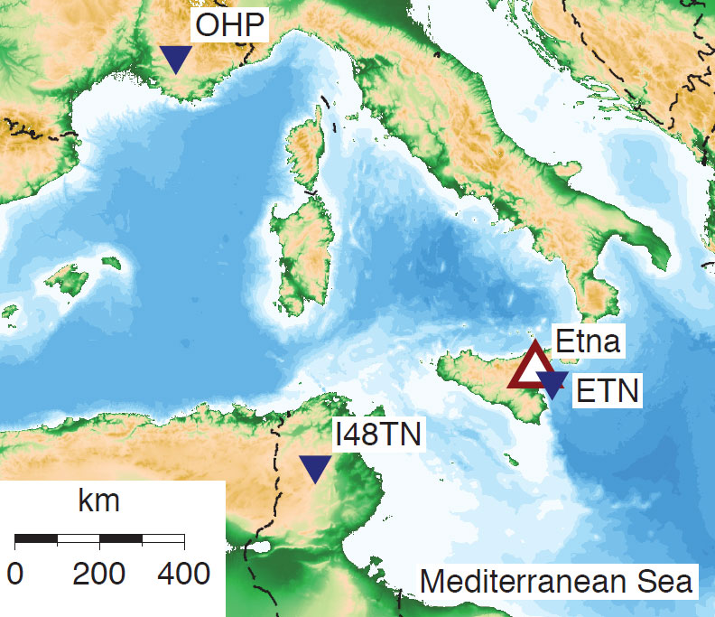
carte-ETNA-OHP

Eruption of Mount Etna on Sicily is well monitored by several experimental infrasound arrays in the western Mediterranean region: ETN operated by University of Firenze in the near field (5 km from Mount Etna), I48TN part of the International Monitoring System (at 550 km) and the array at Observatoire Haute Provence (OHP, at 1040 km). Figure adapted from Assink et al. (2014)

References

  • Matoza, R. S. et al. (2011), Infrasonic observations of the June 2009 Sarychev Peak eruption, Kuril Islands: Implications for infrasonic monitoring of remote explosive volcanism, J. Volcanol. Geotherm. Res., https://doi.org/10.1016/j.jvolgeores.2010.11.022
  • Ulivieri, G., M. Ripepe, and E. Marchetti (2013), Infrasound reveals transition to oscillatory discharge regime during lava fountaining: Implication for early warning, Geophys. Res. Lett., 40, 3008–3013, doi:10.1002/grl.50592. https://doi.org/10.1002/grl.50592
  • Assink, J. D. et al. (2014), Evaluation of wind and temperature profiles from ECMWF analysis on two hemispheres using volcanic infrasound, J. Geophys. Res. Atmos., 119, https://doi.org/10.1002/2014JD021632
  • Tailpied, D., et al. (2016), Assessing and optimizing the performance and infrasound monitoring network, Geophys. J. Int., 208, https://doi.org/10.1093/gji/ggw400
  • Ripepe, M., et al., (2018), Infrasonic Early-Warning for explosive eruption as operational tool for volcanic risk management, J. Geophys. Res., submitted.
  • Marchetti et al. (2018), Infrasound monitoring of volcanic eruptions and contribution of ARISE to the Volcanic Ash Advisory Centers, in: Le Pichon, A., E. Blanc, and A. Hauchecorne (Eds.) Infrasound and middle-atmospheric monitoring: Challenges in middle-atmosphere dynamics and societal benefits Springer Nature, in press. https://www.springer.com/gb/book/9783319751382
  • Credits background-image : Manuel Oliva